Biomass Production Map
What is a Biomass Production Map?
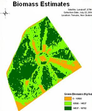
Biomass refers to resources from trees, grasses, agricultural crops or other biological material. The map shows the spatial distribution of the amount of above ground biomass produced within the area of interest indicated by the customer. The map is produced using proprietary algorithms taking advantage of the spectral, spatial and temporal attributes of medium to coarse spatial resolution satellite imagery. We apply a proprietary calibration process to produce an accurate and consistent total biomass production.
How can the map be used?
The product can be used along with our commodity product to determine the location of varieties of biofuels and associated total production.
Product value
The ability to accurately measure the production of our domestic and sustainable resources to provide its fuel from biomass, is key to minimizing our dependence on foreign energy sources. The map can help determine the optimum location and production of biomass conversion plants, and monitor condition over time. The map can also be ingested by climate forecast models as a carbon dioxide sink.
Call GeoSpatial Partners at (303) 513 0092
|