Land Exploration
What is Land Exploration service?
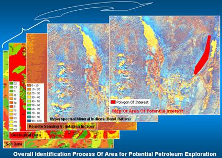
The land exploration service helps generate a map showing areas with potential for petroleum/gas exploration. Most hydrocarbon accumulations have some leakage to the surface affecting above ground rocks and soils through which they move. Changes in mineral composition, illite to kaolinite and vegetation community (vigorous to stressed vegetation) can be an indicator of the presence of hydrocarbon. In fact, hydrocarbon production areas were correlated to minerals and vegetation anomalies detected from ASTER imagery. We use Hyperspectral imagery from ASTER in conjunction with soil data, geological data and advanced data mining tools and knowledge from in-house expert geologists to identify rock/mineral formations and vegetation disturbances indicative of hydrocarbon presence.
How is the information used?
Because imagery used in this process are ortho-rectified, GeoSpatial Partners tailor the feature map such that it fits within the customer’s decision system and handheld field GPS to support further field survey and exploration.
Product Value
Petroleum exploration is conducted on large areas of land and boots-on-the-ground approach for hydrocarbon detection is time consuming and costly. We use high and medium resolutions satellite imagery with their spatial, spectral and temporal characteristics together with ancillary ground data and data mining tools to produce a amp showing areas of the land with interest for potential exploration. The approach is applied on large areas of lands, saving time and cost.
|